

20 Scenic Drives in Ireland: Explore the Best Places to Drive to in Ireland
Updated On: April 28, 2024 by  Yasmin Elwan
There’s something special about the freedom of the open road, especially when it winds its way through the breathtaking landscapes of Ireland. From quaint villages to majestic mountains, Ireland’s diverse scenery is best experienced from behind the wheel of a car. So grab your keys, fuel up your tank, and get ready to embark on a journey through some of the best places to drive to in Ireland. From the moment you hit the road, you’ll be captivated by the beauty and charm of this enchanting country.
Table of Contents
Top 20 Scenic Places to Drive to in Ireland
Embark on a breathtaking journey through Ireland’s stunning landscapes with these top 20 scenic drives.
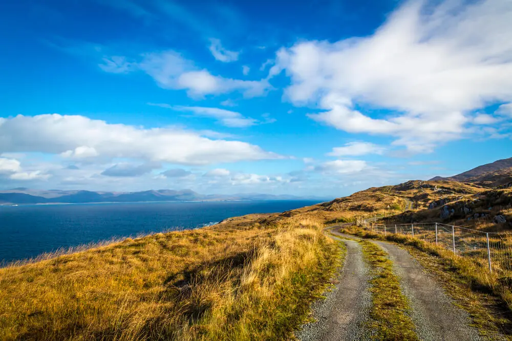
Inishowen 100 (Donegal)
Inishowen 100 is a great drive in Donegal. It takes you around the Inishowen Peninsula. You see cliffs, beaches and old buildings on this route. Some of these are Ireland’s best spots! Take your time to stop at Fort Dunree or Mamore Gap for breathtaking views.
Visit Malin Head, it is Ireland’s most northern point. The name “Inishowen 100” comes from its close to 100-mile length. This makes it perfect for a slow drive on a sunny day or even over two days if you like! A good tip is to plan ahead so you don’t miss any gems along the way!
Copper Coast (Waterford)
Nestled along the southeastern coast of Ireland, the Copper Coast in Waterford is a hidden gem waiting to be discovered. Stretching for approximately 25 kilometres, this rugged coastline boasts stunning cliffs, secluded coves, and sandy beaches, all framed by dramatic sea views. The name “Copper Coast” pays homage to the area’s rich mining history, with remnants of old copper mines dotting the landscape.
As you traverse the scenic coastal road, you’ll be treated to panoramic vistas of the Celtic Sea, with waves crashing against the towering cliffs below. Outdoor enthusiasts will delight in the abundance of hiking trails that meander through the rugged terrain, offering opportunities to explore hidden caves, ancient ruins, and pristine natural landscapes.
Birdwatchers will also find much to admire, as the Copper Coast is home to a variety of seabirds and marine wildlife. Whether you’re seeking adventure, relaxation, or simply a chance to reconnect with nature, the Copper Coast in Waterford promises an unforgettable experience for all who visit.
Northern Glens Trail (Cavan, Fermanagh, Leitrim, Sligo)
The Northern Glens Trail is a breathtaking scenic drive that takes you through the stunning landscapes of Cavan, Fermanagh, Leitrim, and Sligo. As you navigate this route, you’ll be immersed in the beauty of lush green valleys, rolling hills, and serene lakes. From rolling green hills to shimmering lakes and cascading waterfalls, the Northern Glens Trail promises an unforgettable adventure for those willing to hit the road and explore.
Driving Through Cavan
Our journey begins in County Cavan, where narrow country lanes lead through emerald-green pastures dotted with grazing sheep and rustic farmhouses. As you wind your way through the countryside, be sure to make a stop at the Marble Arch Caves Global Geopark, a UNESCO World Heritage Site renowned for its underground caverns and limestone formations. From there, continue on to the charming town of Belturbet, where you can stroll along the banks of the River Erne and soak in the peaceful ambience of this idyllic riverside community.
Exploring Fermanagh
Next, our route takes us into County Fermanagh, known as the “Lakelands” for its abundance of pristine lakes and waterways. Take your time to explore the tranquil waters of Lough Erne, where you can enjoy a leisurely boat ride or try your hand at fishing for trout and pike. Don’t miss the opportunity to visit the stunning Marble Arch Caves, where underground rivers and towering stalactites create a mesmerising subterranean world.
Venturing Through Leitrim
Continuing westward, we arrive in County Leitrim, where rugged mountains and lush forests dominate the landscape. Follow the winding roads through the Glens of Leitrim, a series of picturesque valleys carved out by ancient glaciers. Stop off at Glenfarne Forest Park to stretch your legs and take a leisurely stroll through the tranquil woodlands, keeping an eye out for red squirrels and native bird species along the way.
Discovering Sligo’s Beauty
Our journey concludes in County Sligo, home to some of Ireland’s most iconic landmarks and breathtaking scenery. Take a detour to explore the majestic Benbulbin Mountain, where sheer cliffs and rocky outcrops offer panoramic views of the surrounding countryside. Don’t miss the chance to visit the picturesque village of Drumcliffe, where the final resting place of renowned poet W.B. Yeats overlooks the tranquil waters of Lough Gill.
Ring of Beara (Cork)
The Ring of Beara, located in County Cork and County Kerry on the southwest coast of Ireland, is a hidden gem waiting to be explored. Often overshadowed by its more famous neighbour, the Ring of Kerry, this scenic driving route offers a quieter, more intimate experience of Ireland’s rugged beauty.
As you traverse the winding coastal roads, you’ll be treated to breathtaking views of the Atlantic Ocean, rugged cliffs, and picturesque fishing villages. Along the way, be sure to stop off at charming towns like Kenmare and Castletownbere, where you can sample fresh seafood, browse local craft shops, and soak in the laid-back atmosphere of coastal living.
Lough Corrib (Galway, Mayo)
The Lough Corrib in Galway and Mayo is a must-drive route for anyone looking to experience the stunning natural beauty of Ireland. This picturesque drive takes you around Lough Corrib, the largest lake in the Republic of Ireland.
As you travel along this loop, you’ll be treated to breathtaking views of the lake, lush green countryside, and charming villages. There are also plenty of opportunities to stop and explore, with attractions like Ashford Castle and Cong Village along the way.
Slea Head Drive (Kerry)
Slea Head Drive in Kerry is a must-visit for those looking to explore the stunning beauty of Ireland. This scenic drive takes you along the rugged coastline of the Dingle Peninsula, offering breathtaking views of mountains, cliffs, and sandy beaches.
As you drive along this route, you’ll have the opportunity to stop at picturesque villages like Ventry and Dunquin. History buffs will enjoy visiting ancient sites such as Dunbeg Fort and Gallarus Oratory. Nature lovers will be delighted by the diverse wildlife and birdwatching opportunities along the way.
Causeway Coastal Route (Antrim, Northern Ireland)
The Causeway Coastal Route in Northern Ireland is one of the best scenic drives you can experience. It features attractions like the famous Giant’s Causeway and Carrick-a-Rede rope bridge. Along the way, you can also enjoy panoramic views from Gortmore Viewpoint and explore historical sites like Dunluce Castle.
The rugged coastline and dramatic cliffs make for unforgettable photo opportunities. This drive is perfect for those seeking adventure and natural wonders in Antrim’s beautiful landscape.
Glengesh Pass (Donegal)
Glengesh Pass in Donegal is a magnificent drive that shouldn’t be missed. As you navigate this winding road, surrounded by lush green hills and breathtaking views, you’ll feel like you’ve stepped into a postcard.
The pass connects Ardara and Glencolmcille, taking you through some of Ireland’s most stunning landscapes. Along the way, keep an eye out for sheep grazing peacefully on the hillsides and picturesque villages dotted along the route.
Yeats County Loop (Sligo)
The Yeats County Loop in Sligo is a scenic drive that takes you through the stunning landscapes of W.B. Yeats’ beloved county. This drive is perfect for nature lovers and history buffs, as it offers breathtaking views of mountains, lakes, and rolling green hills.
Along the way, you can explore sites associated with the famous poet, such as Drumcliffe Churchyard, where he is buried. You can also visit beautiful attractions like Glencar Waterfall and Benbulben Mountain. The Yeats County Loop is a must-visit for anyone seeking to immerse themselves in the natural beauty and cultural heritage of Sligo.
Sky Road (Galway)
Sky Road in Galway is a must-visit scenic drive offering breathtaking views of the coastline and surrounding countryside. The route stretches for approximately 20 kilometres and takes you along winding roads that overlook Clifden Bay.
Throughout the journey, you will be treated to stunning panoramic vistas of the Atlantic Ocean, nearby islands, and rolling hills. This makes it an ideal destination for photography enthusiasts looking to capture Ireland’s natural splendour. Along the way, take your time to stop at various lookout points and soak in the awe-inspiring scenery.
Discover charming villages like Clifden, offering a delightful array of local shops, cafes, and restaurants waiting to be explored. Dive into Galway’s captivating history with visits to attractions such as Clifden Castle or by wandering amidst ancient ruins peppered along the route.
Sheep’s Head (Cork)
One of the stunning scenic drives in Ireland that is a must-visit for nature lovers is Sheep’s Head in Cork County. This picturesque route takes you along rugged coastal cliffs and through charming rural landscapes, offering breathtaking views at every turn.
As you drive along Sheep’s Head Peninsula, you’ll have the opportunity to spot grazing sheep, explore hidden coves and beaches, and marvel at the clear blue waters of Bantry Bay. Don’t forget to stop by Sheep’s Head Lighthouse, where you can take in panoramic vistas of the Atlantic Ocean.
Munster Vales (Waterford, Tipperary)
Nestled in the heart of Ireland’s Ancient East, Munster Vales offers a plethora of scenic drives that wind through some of the country’s most enchanting landscapes. From rolling hills and lush valleys to historic castles and picturesque villages, there’s no shortage of beauty to behold along these routes. Whether you’re a nature enthusiast, a history buff, or simply seeking a peaceful escape, Munster Vales has something to offer every traveller. Below are some of the most captivating drives to explore in this stunning region:
- The Knockmealdown Drive: Journey through the rugged beauty of the Knockmealdown Mountains, where winding roads offer breathtaking views of the surrounding countryside. Along the way, be sure to stop off at the iconic Swiss Cottage and the majestic Cahir Castle, both of which offer a glimpse into Ireland’s rich heritage.
- The Comeragh Drive: Meander through the scenic splendour of the Comeragh Mountains, where cascading waterfalls, tranquil lakes, and verdant forests await. Don’t miss the opportunity to explore the magical Mahon Falls and the picturesque Nire Valley, both of which are sure to leave you spellbound.
- The Galtee Drive: Traverse the stunning Galtee Mountains, Ireland’s highest inland mountain range, and marvel at the sweeping vistas that stretch as far as the eye can see. Along the route, discover hidden gems like the Glen of Aherlow, a serene valley nestled between the Galtees and the Slievenamuck Hills, and the enchanting Lough Curra, a crystal-clear lake surrounded by craggy peaks.
- The Blackwater Drive: Follow the meandering course of the River Blackwater as it winds its way through lush green countryside, charming villages, and historic landmarks. Be sure to visit the iconic Lismore Castle, with its magnificent gardens and panoramic views, and the quaint village of Cappoquin, where you can enjoy a leisurely stroll along the riverbank.
Wicklow Mountains (Wicklow)
Nestled just south of Dublin, the Wicklow Mountains offer a spectacular backdrop for some of Ireland’s most scenic drives. As you wind your way through the rugged terrain, you’ll be treated to sweeping vistas of rolling hills, lush forests, and shimmering lakes. One of the most iconic drives in the region is the Wicklow Gap, a twisting mountain road that traverses the heart of the Wicklow Mountains National Park.
Along the way, you’ll pass by towering peaks, ancient monastic sites, and quaint villages, offering plenty of opportunities to stop and soak in the breathtaking scenery. For those seeking a more leisurely drive, the Sally Gap Loop offers a scenic route through the heart of the mountains, passing by picturesque lakes, cascading waterfalls, and heather-covered moors.
Hook Peninsula Coastal Drive (Wexford)
This stunning drive takes you along a scenic route with breathtaking views of rugged cliffs, golden sandy beaches, and beautiful coastal villages. One of the highlights is Hook Lighthouse, the oldest operational lighthouse in the world. Standing tall on a rocky headland, it offers panoramic views of the surrounding ocean. As you continue your drive, you’ll also come across Tintern Abbey, a well-preserved Cistercian monastery dating back to the 13th century.
Other attractions along the way include Duncannon Fort, which played an important role in Ireland’s history; Loftus Hall, known as “Ireland’s most haunted house”; and numerous picturesque fishing villages where you can sample fresh seafood.
Atlantic Drive (Mayo)
Atlantic Drive in Mayo is a scenic drive that offers breathtaking views of the rugged Atlantic coastline. As you cruise along this route, you’ll be treated to stunning vistas of towering cliffs, picturesque beaches, and charming coastal villages. The drive takes you through places like Achill Island and Mulranny, where you can explore beautiful beaches and historical sites and enjoy outdoor activities like hiking and cycling. Nature lovers will also appreciate the diverse flora and fauna found along the drive.
Ring of Kerry (Kerry)
The Ring of Kerry in County Kerry is a must-visit scenic drive in Ireland. The 179-kilometre route takes you through stunning landscapes, charming villages, and historic sites. As you drive along the coast, you’ll be awe-struck by the rugged cliffs and pristine beaches.
Don’t forget to stop at the picturesque towns of Killarney and Kenmare, where you can enjoy delicious local cuisine and immerse yourself in Irish history. Nature lovers will appreciate the breathtaking views of Killarney National Park and the famous Lakes of Killarney.
Boyne Valley (Meath, Louth)
The Boyne Valley in Meath and Louth is a must-visit for nature lovers and history buffs. Along this drive, you can explore ancient ruins, historic sites, and stunning landscapes.
One of the highlights of this route is the UNESCO World Heritage Site of Brú na Bóinne, where you can see Neolithic passage tombs dating back thousands of years. The drive also takes you to Trim Castle, the largest Norman castle in Ireland. As you journey through the picturesque countryside, you’ll be greeted with rolling hills, charming villages, and beautiful views of the River Boyne.
Cooley Peninsula (Louth)
One of the top recommended scenic drives in Ireland is the Cooley Peninsula. This 80km route takes you around the beautiful Cooley Peninsula, starting in Dundalk and ending in Newry.
Along the way, you’ll pass through charming towns like Carlingford and enjoy stunning views of mountains, forests, and coastline. The drive showcases the picturesque beauty of this lesser-known region of Ireland.
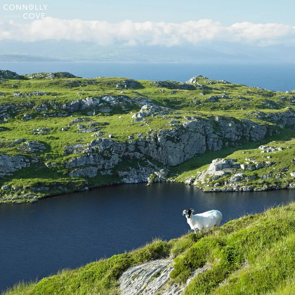
Gleniff Horseshoe (Sligo)
Gleniff Horseshoe in Sligo is a must-visit scenic drive in Ireland. As you travel through this picturesque route, you’ll be surrounded by stunning landscapes and rugged mountains. The beauty of Benwiskin Mountain and the majestic Gleniff Horseshoe Valley await exploration. Additionally, visitors can delve into the area’s rich heritage, including the remains of an old World War II lookout post, adding another layer of intrigue to their journey.
Sally Gap (Wicklow)
If you enjoy scenic drives, the Sally Gap Drive in Wicklow is a must-visit. This stunning drive takes you through the breathtaking Wicklow Mountains, offering picturesque views of rolling hills and lush green landscapes.
As you make your way along the winding roads, keep an eye out for tranquil lakes and cascading waterfalls that add to the natural beauty of this route. Passing by ancient ruins and megalithic tombs offers a glimpse into Ireland’s rich past, adding depth to the journey for all explorers.
Let the engine purr, the windows open wide, and the emerald tapestry of Ireland unwind before you. Each bend in the road unveils a story, a hidden pub, and a breathtaking vista. The wind whispers tales of ancient lore, while the rhythm of the journey washes away the everyday. Whether you chase coastlines carved by the Atlantic’s fury or traverse rolling hills dotted with sheep, remember, the true treasure lies in the open road itself. So, buckle up, embrace the unexpected, and let Ireland’s soul unfold mile by a magical mile.
Exploring Aillwee Caves in County Clare, Ireland
County Clare
01/05/2024

Visiting Glasgow | Ultimate Travel Guide
Scotland
01/05/2024
Discovering Ireland | Explore County Tyrone
County Tyrone
01/05/2024
10 Charming Irish Towns You Must Visit
Ireland
01/05/2024

The Art of Solomon’s Knot: Complete Guide
Culture Exploration
02/05/2024