


Article Summary
What this article covers: How the Giant’s Causeway formed, the full Irish legend behind its name, the formations worth finding on the stones, and what it actually costs to visit County Antrim’s basalt coast.
Who this is for: Travellers planning a trip to Northern Ireland’s north coast, readers researching Irish folklore and Celtic legend, and anyone who wants the geology and the myth in one place without the tourist-board gloss.
Key takeaway: Walking out onto the Giant’s Causeway is free under a public right of way. The National Trust fee buys the Visitor Experience and the car park, not the stones.
Expert insight: “I’ve walked down to the stones at seven in the morning in February, when the car park is empty and the only sound is the sea working away at Port Ganny. That’s when you notice the columns are wet and dark, and that about a third of them shift very slightly underfoot. Every coach that pulls in at eleven o’clock sees a completely different place. If you change one thing about your visit to the Antrim coast, go early.” , Ciaran Connolly, Founder of ConnollyCove
Quick facts:
- The Giant’s Causeway is made up of roughly 40,000 interlocking basalt columns, most of them hexagonal, formed 50 to 60 million years ago during the Paleocene epoch.
- It became Northern Ireland’s first UNESCO World Heritage Site in 1986 and a national nature reserve in 1987.
- Pedestrian access to the stones is free via a public right of way. The National Trust charges for the Visitor Experience, on-site parking, guided tours and audio guides.
Table of Contents
What is the Giant’s Causeway?
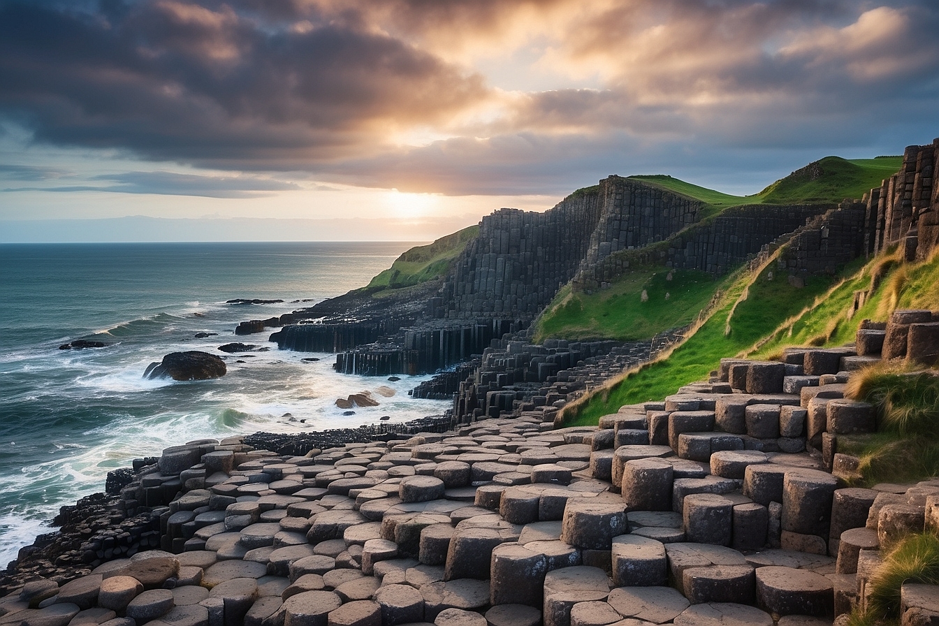
The Giant’s Causeway is an area of roughly 40,000 interlocking basalt columns on the north coast of County Antrim, Northern Ireland, formed by volcanic activity 50 to 60 million years ago. It became Northern Ireland’s first UNESCO World Heritage Site in 1986 and a national nature reserve the following year. It sits a few miles north-east of the village of Bushmills, about an hour and a quarter from Belfast by car.
Stand on it on a wet March morning and the first thing that strikes you is not the scale. It is how ordinary the stones look up close. Flat-topped, grey-brown, packed together like a badly laid pavement, running down off the cliff foot and disappearing under the Atlantic. The drama is in what made them, and in the two completely different stories Ireland has always told about that: one about cooling lava, and one about a giant called Fionn mac Cumhaill.
This guide covers both. The geology first, because the mechanism is stranger than most summaries let on. Then the legend of Fionn and Benandonner as it is actually told in Ulster, including the part almost every tourist retelling leaves out. After that, the formations worth walking to, the Scottish half of the same lava flow, and honest guidance on what a visit costs.
ConnollyCove is an Ireland-based travel and culture platform covering Irish heritage, Celtic mythology and destinations worldwide, and the Antrim coast is home ground for us. This is written the way we would explain it to a friend flying into Belfast next week. If you want the legend on its own and at full length, our longer telling of the Finn McCool story goes further into the Ulster variants than there is room for here.
How the Giant’s Causeway formed
The Causeway formed between 50 and 60 million years ago, when molten basalt pushed up through the chalk beds of what is now County Antrim and spread out as a thick lava plateau. As that lava cooled it shrank, and the shrinking cracked it into columns. The detail that matters most, and the one most short explanations get wrong, is that the cooling was slow and even rather than fast. Quick cooling produces glassy, irregular rock. It is the slow, uniform loss of heat through a deep pool of lava that lets fractures organise themselves into a regular geometric pattern.
Think of a dried-out riverbed or a cracked mud flat. The surface contracts, cracks appear, and those cracks meet each other at roughly equal angles because that arrangement releases the most stress for the least new crack surface. In a lava flow the same thing happens, except the cracks then propagate downwards through the cooling mass rather than staying at the surface. What you are walking on is the top of a fracture network that runs metres down into the rock.
The columns also broke horizontally as they cooled, into segments the guides here call biscuits. Many of those breaks left a convex bottom face sitting in a concave top face, which geologists describe as ball-and-socket jointing. You can see it clearly on the broken column ends near the water line at Port Noffer. The British Geological Survey treats the Antrim basalts as part of the British Paleogene Igneous Province, the same volcanic episode that produced the Inner Hebrides. ConnollyCove films along this stretch of coast regularly, and the ball-and-socket joints are far easier to pick out in person than in any photograph.
Why are the columns hexagonal?
Most of the columns are hexagonal because six-sided cracking is the most efficient way for a cooling sheet of rock to relieve stress. Not all of them are. Counts on site turn up columns with four, five, seven and eight sides, and a small number with three. Hexagons dominate because they tile a flat surface with no gaps while keeping total crack length low, which is the same reason honeycomb cells end up hexagonal.
The regularity is not perfect, and that is worth saying plainly, because photographs tend to flatter it. Walk twenty metres across the Grand Causeway and you will find columns that are visibly lopsided, columns ground down by the sea into shallow bowls that hold rainwater, and whole patches where the pattern breaks up entirely.
Is the Giant’s Causeway natural or man-made?
The Causeway is entirely natural. No part of it was cut, laid or shaped by people. The question comes up constantly, and it is a reasonable one, because the columns really do look quarried and set by hand, with flat tops at a consistent height and joints tight enough that you can rarely get a coin into them.
That appearance is what generated the legend in the first place. Early Gaelic communities on this coast saw a paved road of regular stones running out to sea in the direction of Scotland, and drew the obvious conclusion. The geological explanation only arrived in the eighteenth century, and even then it was fought over for decades between geologists who thought the basalt had precipitated out of water and those who correctly identified it as cooled lava.
The story of the Giant’s Causeway
The story behind the Giant’s Causeway is that the Irish giant Fionn mac Cumhaill, anglicised as Finn McCool, built a stone road across the sea to fight the Scottish giant Benandonner, then had to be saved from the fight by his wife Oonagh. Most retellings stop at the road. The Ulster tradition does not, and the second half is the better half.
Fionn belongs to the Fenian Cycle, or an Fhiannaíocht, one of the four great cycles of Irish myth. He leads the Fianna, the roving warrior bands of early Ireland, and he appears across hundreds of tales that have nothing to do with the Causeway at all. Placing him here is a specifically Antrim development of a national figure, which is why his name is attached to so much of this coastline. ConnollyCove documents Celtic mythology alongside the real places the stories are set in, and this site is the clearest example of that connection anywhere in Ireland.
Oonagh’s trick, the part most retellings leave out
In the fuller telling, Fionn crosses to Scotland, sees the size of Benandonner, and runs home badly frightened. Oonagh is the one who solves it. She bakes a batch of griddle bread with iron pans baked into the loaves, dresses Fionn in a nightgown and puts him in a cradle. When Benandonner arrives looking for his fight, she feeds him the iron-laden bread, which breaks his teeth, then hands a soft loaf to the enormous baby in the cradle, who eats it without difficulty. Benandonner works out that if the infant is that size and that strong, the father is not a fight worth having. He runs for Scotland, tearing up the causeway behind him so nothing can follow.
The point of the story in its original setting is not brute strength. It is that a woman’s wit beats a giant’s arms, a pattern that recurs throughout Irish folklore and is systematically sanded off in the three-sentence version printed on visitor signage. Oonagh, or Úna, appears in several Fenian tales in her own right.
What the name means in Irish and Ulster-Scots
In Irish the site is Clochán an Aifir, roughly “the stepping stones of the giant”. It also appears as Clochán na bhFómharach, “the stepping stones of the Fomorians”, linking the stones to the ancient sea-raiding race who fought the Tuatha Dé Danann. Clochán is the same word used for the beehive huts of the west coast, and it means a stepping-stone crossing or a dry-stone structure.
In Ulster-Scots, still spoken across north Antrim, it is Tha Giant’s Causey. Fionn mac Cumhaill is said roughly as “fyun mac cool”, and the name means “Finn, son of Cumhall”, with fionn carrying the sense of fair, bright or white-haired. ConnollyCove produces guides to the Irish language as it is actually spoken, not just as it appears on signage, and our collection of traditional Irish proverbs is a good next step for anyone who enjoys this side of it.
The Scottish connection: Fingal’s Cave and the same lava flow
The Causeway and Fingal’s Cave on the Scottish island of Staffa are remnants of the same volcanic event, which is the rare case of a myth turning out to be geologically literal. Both sites sit on basalt laid down by the British Paleogene Igneous Province, and both show the same columnar jointing produced by the same slow cooling. A road of stone really did once connect the two coasts, in the sense that a continuous sheet of lava did.
Staffa’s columns arch into a sea cave famous for its acoustics rather than its pavement. Fionn’s Scottish counterpart in Gaelic tradition is Fingal, and the cave carries his name for exactly the reason you would expect.
From the clifftop path above the stones on a clear day you can see the Scottish coast. It is easy to understand how a community looking at a stone road pointing straight at it arrived at the story they did. This is the connection almost no international guide makes, and it is worth making, because it ties Antrim to Argyll, Irish myth to Scottish myth, and the geology to the folklore in a single line.
Formations to find on the stones
Five formations account for most of the photographs taken here, and they are spread over a walk of well under a mile. You do not need a guide to find them, but you do need to know they exist, because the signage is sparse once you are down on the rocks. Based in Ireland, ConnollyCove covers the Causeway Coast in both written guides and video, and this is the section we get the most questions about.
The Grand Causeway, the Wishing Chair and the Giant’s Boot
The Grand Causeway is the main pavement, the widest of three rocky promontories and the part everyone means when they say they have been here. It runs out from the cliff foot and drops away under the water.
The Wishing Chair sits within it: a natural seat formed where a column has weathered lower than its neighbours, with the surrounding columns forming a back and arms. It has been polished smooth by several centuries of visitors. Local tradition holds that wishes made sitting in it come true. There is also a persistent claim that women were once excluded from sitting in it, which we have not been able to source to anything reliable.
The Giant’s Boot lies further along, past Port Noffer, and is a single wedge of basalt weathered into a convincing shoe shape. The commonly quoted size, somewhere in the low nineties, is a piece of visitor-centre folklore rather than a measurement, and we would treat it as such. It is a fifteen to twenty minute walk beyond the main pavement, and a great many visitors turn back before reaching it.
The Organ, the Chimney Stacks and the Camel’s Back
The Organ is a run of tall, slender columns standing vertically in the cliff face above the Red Trail, so called because it resembles a set of pipes. It matters geologically as well as visually: it shows that the columns are not confined to the shoreline pavement but extend up through the cliff, in two distinct layers geologists call the colonnade and the entablature.
The Chimney Stacks are isolated pillars standing clear of the cliff at Lacada Point, weathered out from the rock behind them. The Camel’s Back, a long humped ridge near the start of the walk, is the one most people photograph without knowing its name.
How the Causeway became a visitor attraction
The site was known locally for centuries, but it entered wider European awareness after the Bishop of Derry visited in 1692 and a paper describing it was presented to the Royal Society in London shortly afterwards by Sir Richard Bulkeley. Calling that a discovery, as many accounts still do, is a considerable stretch. People had been living beside these stones and naming them in Irish for a very long time.
What actually made the site famous was a painter. The Dublin artist Susanna Drury spent months on the coast and produced two detailed watercolours in 1739, winning the first premium awarded by the Royal Dublin Society in 1740. Engravings of her work circulated across Europe and were reproduced in the French Encyclopédie, which put the Causeway into the scientific argument about the origins of basalt. Tourism followed through the nineteenth century, and the National Trust took over care of the site in the 1960s. ConnollyCove covers Irish heritage sites and the history of how they came to be visited, which is often a better story than the attraction itself.
The Giant’s Causeway Tramway
The Causeway Tramway opened in 1883, running roughly fifteen kilometres from Portrush along the coast, and was promoted at the time as the world’s first long electric railway. It closed in 1949. Today the Giant’s Causeway and Bushmills Railway runs heritage trains over part of the old course, between Bushmills and a halt near the stones, on a narrow-gauge line built in the 1990s.
Visiting the Giant’s Causeway: what’s free and what you pay for
You can walk to the Giant’s Causeway stones for free. A public right of way runs down to the shore, and the National Trust states this plainly on its own site. What the Trust charges for is the Visitor Experience, which covers the on-site car park, the exhibition, a guided tour with their storytelling team, audio guides in eleven languages, the shuttle bus, the shop and the café. Ciaran Connolly founded ConnollyCove to help travellers find the cultural depth behind the places they visit, and being straight about what a visit actually costs is part of that.
The catch is parking, and it is worth being direct about it. The on-site car park is reserved for Visitor Experience ticket holders and National Trust members. Walkers arriving by car are directed to the Causeway Coast Way car park at Innisfree Farm on Causeway Road, which charges per vehicle through the JustPark app and is free to National Trust members. So for a driver, the free option is a parking fee rather than nothing. There is also a discounted park-and-ride arrangement through the Bushmills Visitor Information Centre at Dundarave car park.
| What you get | Visitor Experience ticket | Walking in free |
|---|---|---|
| Access to the basalt columns | Yes | Yes |
| On-site car park at the centre | Yes | No |
| Exhibition and audio guide | Yes | No |
| Guided tour with a storyteller | Yes | No |
| Shuttle bus down to the stones | Yes | No |
| Café, shop and toilets | Yes | Toilets and café accessible |
| Clifftop and coastal trails | Yes | Yes |
Prices and opening arrangements change, so check the National Trust’s official page before you travel rather than trusting any figure printed in a guide.
The four walking trails
Four waymarked routes run from the Visitor Centre. The Blue route is the short direct walk down to the stones, roughly a kilometre and ten to fifteen minutes each way. The Red route climbs the Shepherd’s Steps for the clifftop view over Port Noffer. The Yellow route joins the long-distance Causeway Coast Way. The looping section of the Green trail is the accessible option, suitable for wheelchairs, powered scooters and prams.
Getting there from Belfast, Derry and Dublin
Driving from Belfast takes around an hour and a quarter on the inland route through Ballymena, or closer to two and a half hours on the coast road, which you should take if you have the day. From Derry it is about an hour. From Dublin, allow three hours and a quarter each way, which makes a day trip long but workable.
By public transport, take the train from Belfast Lanyon Place to Coleraine and connect by bus from there. Translink publishes current timetables and runs the seasonal Causeway Rambler service along the coast.
Most visitors base themselves in Belfast for the city and run the coast as a day trip. Our guide to affordable things to do around Belfast pairs well with a north coast day.
Current conditions and seasonal information
The Causeway is exposed Atlantic coastline and the weather governs everything. ConnollyCove has filmed here across every season, and the difference between a July afternoon and a January morning is not marginal. May to September gives the most settled conditions and the longest daylight, with sunset after ten o’clock in June. Winter brings short days, frequent gales and genuinely dangerous conditions on the lower stones during high seas, though it also brings an empty site and the most dramatic light of the year.
Coach traffic is the other seasonal variable. Tour buses from Belfast and Dublin cluster between roughly half past ten and half past three. Arriving before nine or after five transforms the experience, and in high summer that is comfortably within daylight hours. The stones nearest the water carry wet kelp and are slippery in any season, so wear something with grip. Pre-booking a Visitor Experience slot is strongly advised in summer.
Two nearby stops are worth building in. Portballintrae is a quiet harbour village about ten minutes west, good for a walk when the main site is busy.
A little further on, Whiterocks Beach gives you chalk cliffs and a long strand, and it stays quiet even in August.
ConnollyCove covers both on the wider coastal route. One practical note for anyone crossing from the Republic: Northern Ireland uses pounds sterling, not euro.
Frequently asked questions about the Giant’s Causeway
Is the Giant’s Causeway free to visit?
Yes. A public right of way runs down to the stones and you can walk out onto them without paying admission. The National Trust confirms this on its own website. What is ticketed is the Visitor Experience: the exhibition, guided tour, audio guides, shuttle bus and the on-site car park. Drivers should note that the on-site car park is reserved for ticket holders and members, so walking in free usually still means paying for parking at the separate Causeway Coast Way car park, or arriving by bus, bike or on foot.
Where is the Giant’s Causeway?
It sits on the north coast of County Antrim in Northern Ireland, a few miles north-east of the village of Bushmills. Northern Ireland is part of the United Kingdom, not the Republic of Ireland, which matters for currency and mobile roaming. Belfast is around an hour and a quarter away by car and Derry about an hour. The nearest railway station is Coleraine, with bus connections on to the coast.
How was the Giant’s Causeway formed?
It formed 50 to 60 million years ago, when molten basalt intruded through chalk beds and spread out as a thick lava plateau. As the lava cooled slowly and evenly it contracted, and the contraction cracked it into a network of mostly hexagonal columns that propagated downwards through the mass. The columns then fractured horizontally into segments, often leaving ball-and-socket joints where a convex face sits in a concave one. The same volcanic episode produced Fingal’s Cave in Scotland.
Why is the Giant’s Causeway hexagonal?
Six-sided cracking is the most efficient way for a cooling sheet of rock to release stress, using the least total crack length to cover the most area. It is the same geometry that produces honeycomb cells and dried mud flats. Not every column is a hexagon: four, five, seven and eight-sided columns all occur here, and a few have three sides. The hexagons dominate rather than monopolise.
What is the story behind the Giant’s Causeway?
Irish legend holds that the giant Fionn mac Cumhaill, known in English as Finn McCool, built the causeway as a road to Scotland to fight the giant Benandonner. In the fuller Ulster telling, Fionn sees the size of his opponent and flees home, and his wife Oonagh saves him by disguising him as an infant and serving Benandonner bread with iron pans baked inside. Benandonner breaks his teeth, sees the size of the baby, and runs for Scotland, destroying the causeway behind him.
Was Game of Thrones filmed at the Giant’s Causeway?
No. It was not a Game of Thrones filming location, despite appearing on almost every Game of Thrones tour itinerary from Belfast and Dublin. The real Antrim locations are nearby: Ballintoy Harbour stood in for Lordsport on the Iron Islands, the Dark Hedges at Stranocum played the Kingsroad, Cushendun Caves appeared in season two, and Larrybane Quarry sits beside the Carrick-a-Rede rope bridge. Tours bundle the Causeway in because it is ten minutes from Ballintoy.
How long do you need at the Giant’s Causeway?
Two to three hours suits most visitors. That covers the walk down the Blue route, time on the Grand Causeway itself, the walk out to the Giant’s Boot, and a return via the Shepherd’s Steps and the clifftop Red route. Adding the exhibition takes it closer to three and a half. If you only want to see the stones and you are dropped off, an hour is enough, though it is a rushed hour.
Can you walk on the stones at the Giant’s Causeway?
Yes, walking directly on the basalt columns is permitted and is the whole point of the place. Take care near the water line, where the columns are covered in wet kelp and become extremely slippery, and watch the sea state in winter. The National Trust asks visitors not to wedge coins into the joints, a habit that expands with corrosion and splits the rock.
How does the Causeway connect to Fingal’s Cave?
They are two surviving fragments of the same volcanic event. The lava flows that produced the Antrim columns also produced the basalt of Staffa in the Scottish Inner Hebrides, where the columns form the walls of Fingal’s Cave. Both belong to the British Paleogene Igneous Province. The folklore followed the geology: a stone road pointing towards Scotland, with matching stone at the far end, made the story of a giant’s causeway an entirely logical reading of the evidence.
Plan your visit to the Causeway coast
The Causeway rewards preparation more than most attractions, because the difference between arriving at nine and arriving at noon is the difference between two different places. Go early, take the clifftop route back rather than retracing the road, and build in an hour for Bushmills or Portballintrae afterwards. That single change does more for a visit than anything else we could tell you.
ConnollyCove produces in-depth guides to Irish heritage, Celtic mythology and travel across Ireland and further afield, and the north Antrim coast is one of the areas we cover most closely.
For more of the region, start with our Northern Ireland travel guide, which sets the coast in the context of the rest of the country.
If the folklore is what brought you here, we cover the same ground inland in our piece on Ireland’s fairy forts.
There is more on the symbolic side of the same tradition in our guide to sacred animals in Celtic belief.
Travellers pairing the coast with a city day will find plenty at Titanic Belfast, around ninety minutes back down the road.
You can also watch our walking footage of the stones on the ConnollyCove YouTube channel.


