


Carnlough-A Beautiful Antrim Fishing Village and Harbour
Updated On: April 07, 2024 by  Noha Nabil
Tucked away along the windswept shores of County Antrim, Ireland, lies the enchanting village of Carnlough. With its rugged cliffs, quaint harbour, and vibrant community, this coastal haven beckons travellers seeking an authentic Irish experience. Steeped in history and surrounded by breathtaking natural beauty, Carnlough is a destination. It offers visitors a glimpse into a world where time seems to stand still, and the sea sings its timeless melody. Join us as we embark on a journey to discover the charm and allure of this hidden jewel on the Antrim Coast.
A Coastal Haven
Carnlough’s allure begins with its breathtaking coastal setting. Situated along the Antrim Coast Road, a designated Area of Outstanding Natural Beauty, the village boasts dramatic views of the Irish Sea and rugged cliffs that stretch as far as the eye can see. The harbour, nestled within a sheltered bay, provides a serene sanctuary for fishing boats and yachts, while the surrounding hillsides offer countless opportunities for hiking and exploration.
The village itself is a delightful blend of old-world charm and modern amenities. Quaint cottages adorned with vibrant flowers line the narrow streets, leading visitors past cosy pubs, charming shops, and welcoming bed and breakfasts. The sound of seagulls fills the air as locals and tourists alike stroll along the promenade, taking in the sights and sounds of this idyllic seaside retreat.
A Rich Maritime Heritage
For centuries, Carnlough has been intimately tied to the sea, its history shaped by the ebb and flow of the tide. Originally a tiny fishing hamlet, the village grew in prominence during the 19th century with the development of its harbour, which served as a vital hub for the local fishing industry. Today, while the fishing fleet may be smaller, the harbour remains a focal point of community life, bustling with activity as boats come and go with the day’s catch.
One of Carnlough’s most iconic landmarks is Piers Island, a tiny islet offshore from the harbour. Legend has it that the island was created by the mythical Irish giant Finn McCool, who is said to have thrown a massive stone into the sea, forming the rocky outcrop that now stands as a testament to his strength and ingenuity. Today, Piers Island is a popular destination for visitors, who can reach it via a short walk along the harbour wall.
Exploring Carnlough’s Charms
Carnlough offers visitors a wealth of attractions to explore, from historic landmarks to natural wonders. The village’s most famous landmark is undoubtedly the Londonderry Arms Hotel, a grand Georgian mansion that once served as the residence of Sir Winston Churchill’s family. Today, the hotel offers luxurious accommodations and fine dining, giving guests a taste of Carnlough’s aristocratic past.
A visit to Carnlough Heritage Hub is necessary for those interested in history. Housed in a beautifully restored 19th-century building, the hub showcases the village’s maritime heritage through interactive exhibits, artefacts, and archival materials. Visitors can learn about Carnlough’s fishing industry, its connections to the broader world, and the lives of the people who have called the village home over the centuries.
The Harbour
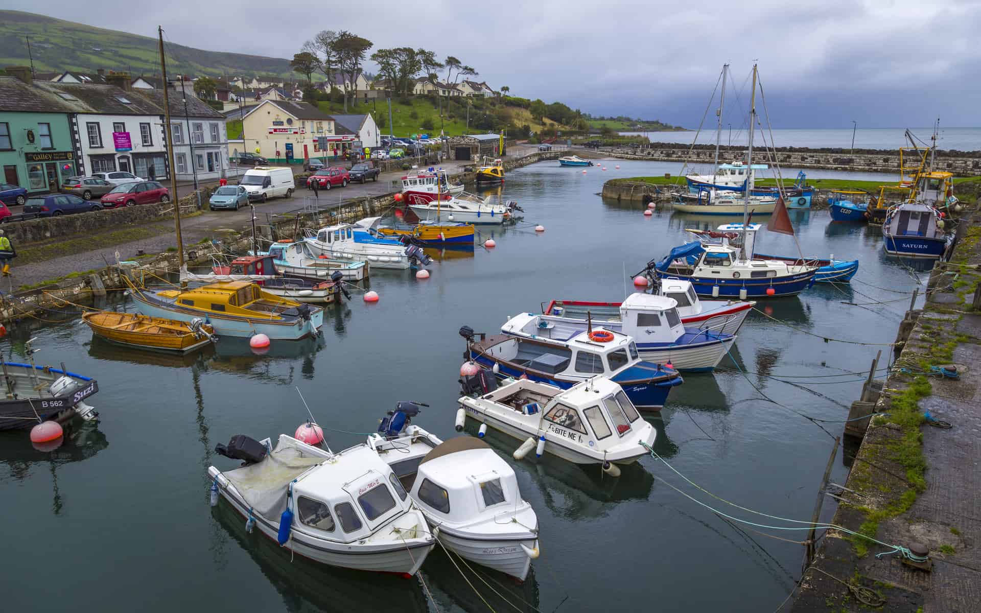
At the heart of Carnlough lies its charming harbour, which has been the focal point of the village for centuries. Built in the 1850s by local landlord Thomas John Bellingham, the harbour served as a vital lifeline for the fishing community, providing shelter for fishing vessels and facilitating the transport of goods to and from the village.
Today, Carnlough Harbour remains a bustling hub of activity, with fishing boats bobbing gently in the water and colourful buildings lining the waterfront. Visitors can stroll along the harbour wall, taking panoramic views of the surrounding coastline and the majestic Glencloy Valley. The harbour’s tranquil atmosphere and stunning scenery make it a popular destination for photographers and artists seeking inspiration from the natural beauty of the Antrim coast.
Embracing Community Spirit
However, what truly sets Carnlough apart is its warm and welcoming community spirit. Whether you’re a first-time visitor or a longtime resident, you’ll be greeted with open arms and a friendly smile wherever you go. From the lively atmosphere of the village’s pubs and restaurants to the warmth of its local shops and businesses, Carnlough’s residents take pride in sharing their corner of the world with visitors from near and far.
The village hosts various festivals and events throughout the year that celebrate its heritage and culture. From the annual Seafood Festival, which showcases the sea’s bounty with delicious food and live music, to the colourful May Day celebrations, complete with traditional dances and parades, there’s always something happening in Carnlough to bring the community together.
Cultural Heritage and Local Traditions
In addition to its natural beauty, Carnlough boasts a rich cultural heritage and a vibrant community spirit evident in its local traditions and events. Throughout the year, the village plays host to various festivals and celebrations, from traditional music sessions to seafood feasts, where visitors can experience the warmth and hospitality of the local people.
One of the highlights of Carnlough’s cultural calendar is the annual Harbour Festival, a weekend-long celebration of the village’s maritime heritage. Featuring live music, dance performances, boat races, and culinary delights, the festival attracts visitors from near and far who experience the unique charm and camaraderie of Carnlough’s fishing community.
Preserving Carnlough’s Heritage for Future Generations
As Carnlough continues to evolve and adapt to the modern world, there is a growing recognition of preserving its heritage and character for future generations. Local conservation efforts aim to protect the village’s historic buildings, natural landscapes, and cultural traditions, ensuring that Carnlough remains a cherished destination for years.
Through heritage walks, educational programs, and community engagement, residents and visitors alike are encouraged to appreciate and safeguard Carnlough’s unique identity and legacy. Carnlough can continue to thrive as a beacon of beauty, history, and community spirit on the Antrim coast by working together to celebrate its past and embrace its future.
Exploring Nearby Attractions
While Carnlough itself is a treasure trove of natural beauty and cultural heritage, the surrounding area of County Antrim offers even more attractions and destinations to explore. From iconic landmarks to hidden gems, there’s no shortage of things to see and do near Carnlough. Here are some notable attractions worth visiting during your trip to this enchanting corner of Northern Ireland:
1. The Glens of Antrim: Just a short drive from Carnlough, the Glens of Antrim offers a spectacular landscape of lush green valleys, cascading waterfalls, and ancient woodlands. Visitors can embark on scenic drives along the Antrim Coast Road, stopping to explore charming villages like Cushendall, Cushendun, and Glenariff, known as the “Queen of the Glens” for its breathtaking beauty.
2. Glenariff Forest Park: Glenariff Forest Park is a nature lover’s paradise in the heart of the Glens. Boasting a network of walking trails that meander through ancient woodlands and alongside rushing waterfalls, the park offers endless opportunities for hiking, picnicking, and wildlife spotting. The panoramic views from the famous “Queen’s View” overlook are not missed.
3. The Giant’s Causeway: One of Northern Ireland’s most iconic landmarks, the Giant’s Causeway is a UNESCO World Heritage Site and a must-see attraction for visitors to the region. Formed millions of years ago by volcanic activity, the Causeway is renowned for its unique hexagonal basalt columns, which form a dramatic staircase leading into the sea. Legend has it that the Irish giant Finn McCool built the Causeway as a pathway to Scotland.
4. Carrick-a-Rede Rope Bridge: Thrill-seekers will delight in the opportunity to cross the exhilarating Carrick-a-Rede Rope Bridge, which spans a 30-meter chasm between the mainland and the tiny island of Carrickarede. Initially used by fishermen to access their salmon nets, the bridge now offers stunning views of the rugged coastline and the sparkling waters below.
5. Dunluce Castle: Perched dramatically on the edge of a cliff overlooking the Atlantic Ocean, Dunluce Castle is a medieval fortress steeped in history and legend. Once the seat of the powerful MacDonnell clan, the castle is said to be haunted by the ghost of Maeve Roe, a young woman who fell to her death from the cliffs below.
6. Bushmills Distillery: Whiskey enthusiasts won’t want to miss a visit to the Old Bushmills Distillery, the oldest licensed whiskey distillery in the world. Founded in 1608, the distillery offers guided tours that provide insight into the whiskey-making process and the opportunity to sample some of their award-winning spirits.
7. Rathlin Island: A short ferry ride from the mainland brings visitors to Rathlin Island, a tranquil haven of rugged beauty and rich wildlife. Home to puffins, seals, and rare bird species, Rathlin is a paradise for nature lovers and outdoor enthusiasts. The island also boasts historic sites such as the ruins of a 13th-century castle and the renowned West Light Seabird Centre.
Conclusion
From the natural wonders of the Glens of Antrim to the iconic landmarks of the Giant’s Causeway and Dunluce Castle, the area surrounding Carnlough is teeming with attractions waiting to be discovered. Whether you’re seeking adventure, history, or simply a chance to immerse yourself in the breathtaking beauty of the Antrim coast, there’s something for everyone to enjoy in this enchanting corner of Northern Ireland. So why not extend your stay in Carnlough and explore all that this captivating region has to offer?

The Absolute Guide to the Best Restaurants in Bath, England: Unveiling the Culinary Gems of Bath!
Food and Cuisine
24/04/2024

Planning a Trip to Scotland: Your All-Inclusive Guide to Exploring the Great Highlands
Travel Guides
23/04/2024

Your Ultimate Guide to Explore the Top Castles in Kent, England
England
23/04/2024

Weather in Ireland in May: A Guide to Climate, Temperature, and What to Wear
Ireland
23/04/2024
Top Castles to Stay in Edinburgh for an Unforgettable Accommodation Experience
Scotland
23/04/2024