


Beautiful Ballygally and Ballintoy, County Antrim
Updated On: March 11, 2024 by  Maha Yassin
Have you seen the beauty of Northern Ireland? It is too magnificent to ever miss out on it. The country has vast green fields, forests, beautiful mountains, and uneven coastlines. For fantasy literature fans, it feels like walking around George R. R. Martin’s Westeros and being part of his world!
Guess what? Ballygaly and Ballintoy in County Antrim are THE filming location of HBO’s highly popular adaptation of Game of Thrones! No wonder the city has rapidly become one of the most visited destinations, thanks to the fans of Game of Thrones. These vast landscapes and beautiful towns have become the real-life Westeros, attracting Game of Thrones fans from around the globe to come and immerse themselves in the fantasy world.
The Towns of Ballygally and Ballintoy
Ballygally is a small village located on the Antrim coast in Northern Ireland. It is known for its picturesque scenery, including the iconic Ballygally Castle, which dates back to the 17th century. The town is a popular destination for tourists seeking a peaceful getaway with stunning views of the Irish Sea and the surrounding countryside. Ballygally also has a rich history, with evidence of human settlement dating back over 9,000 years.
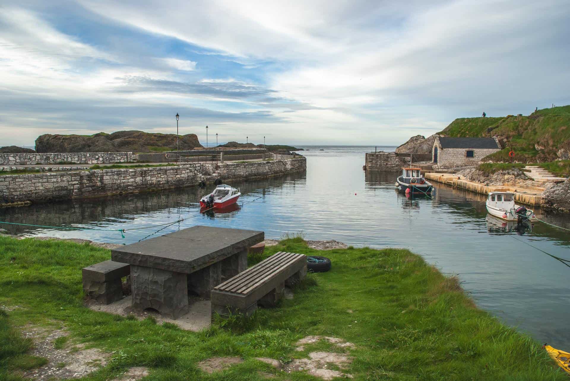
Nearby, the village of Ballintoy is another charming coastal town with a unique character. Ballintoy is famous for its stunning coastline, rugged cliffs, and quaint harbour, making it an ideal spot for outdoor enthusiasts and photographers. The area also boasts several Game of Thrones filming locations, attracting fans of the hit TV show to explore the beautiful landscapes that served as a backdrop for the epic series.
Both Ballygally and Ballintoy are surrounded by natural beauty and offer a peaceful escape from the hustle and bustle of city life. Whether visitors are interested in exploring historical landmarks or simply taking in the breathtaking scenery, these towns provide a serene and captivating experience for all who visit.
The Story of Ballygally Castle
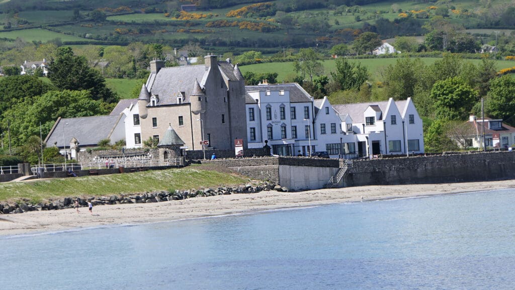
You deserve to visit many attractions in both Ballygally and Ballintoy. However, the one place you absolutely can’t miss is Ballygally Castle! Ballygally Castle is a stunning 17th-century castle located in County Antrim, Northern Ireland. The castle is steeped in history and has a fascinating story behind it. Legend has it that the castle is haunted by the ghost of Lady Isabella Shaw, who was locked in a room by her husband and fell to her death while trying to escape. Despite this haunting tale, the castle is now a luxurious hotel that offers guests a unique and memorable stay.
The castle has been beautifully restored and offers a range of modern amenities while still retaining its historic charm. The stunning coastal location provides breathtaking views of the Antrim coast and the Irish Sea, making it the perfect setting for a romantic getaway or a special event. The castle also offers guided tours for those interested in learning more about its history and the ghostly tales surrounding it.
Whether you are looking for a relaxing retreat, a romantic escape, or a unique wedding venue, Ballygally Castle has something special. Its rich history, stunning setting, and luxurious accommodations make it an unforgettable destination for anyone visiting Northern Ireland.
Places to Visit While in Ballygally Castle
Aside from the ghosts’ stories, Ballygally Castle should be on your to-go list. The castle lies on the Causeway Coastal Route and overlooks the Irish Sea. That, in itself, is a good enough reason to go and enjoy an eccentric scenery. However, there are a lot of stunning places to explore while being there.
The best part is that you also get to explore the place on foot. Some tourist attractions lie within walking distance. Besides, you can enjoy a light stroll on the beach across the hotel and enjoy the picturesque scenes. Here are some of the best attractions to visit close to Ballygally Castle:
Old Bushmills Distillery
Are you a whiskey lover? Then Bushmills Distillery is a must-visit! It is one of the most prominent distilleries in Bushmills, County Antrim. This distillery is behind the Bushmills brand, which sells fine whiskey. Moreover, the water used in the production comes from Saint Columb’s Rill. It became a tourist attraction thanks to the fine whiskey it produces. People love knowing all about their favourite drinks, so they go and see for themselves.
Carrickfergus Castle
If you stay in the Ballygally Hotel, you should visit Carrickfergus Castle. It’s a Norman Irish castle and one of the most significant in Northern Ireland and County Antrim. The castle’s name comes from the Irish version cairn of Fergus or Carraig Ḟergus; Fergus means Strong Man. Probably, the reason behind its name was the fact that it played a significant military role for many years.
Besides, it has been among the structures that have survived since the Medieval Era. Currently, the waters that used to surround the castle are much less. Before land reclamation, water surrounded most parts of the castle.
Whitepark Bay
While in Ballygally, you should never miss out on such an eye-pleasing site as Whitepark Bay! If you reside in Ballygally Castle, you will hear about it. It is nearby, and most residents pass there for a magnificent experience. The fantastic bay features vast golden sands stretching along North Antrim’s coast. It sits right on the Causeway Coastal route and is about an hour and a half from the hotel. The sandy beach is not only a tourist attraction, but also the locals happen to adore it as much. You must go there if you are so much into strolling around sandy beaches and exploring the shoreline.
A Game of Thrones Tour Around Ballygally Castle
We have already mentioned it, but repeatedly doing so is quite entertaining. The cast of Game of Thrones has stayed in Ballygally Hotel for days to film the show. A lot of scenes took place within the castle itself. However, there are other locations around where scenes were filmed. Check out the top locations where the thrilling scenes of our favourite show come to pass.
Audley’s Field and Castle in County Down
Northern Ireland seems to possess more than a few castles, and they are all equally magnificent! Around 1210, a Norman family arrived in Northern Ireland and resided there. After them, the Audley’s Castle got its name. Near Audley’s Castle lies another one known as Castle Ward; it is just five minutes away from one another.
The Audley’s Castle made an appearance in Game of Thrones, where Robb Stark hid his own army. He used this fortification to keep his army away while preparing them to face the Lannisters. Beside the Castle, there is also Audley’s field. Remember the battle of Oxcross? It took place in that field right beside the castle. Talisa and Robb met on the same field, and eventually, the notorious Red Wedding happened.
Ballintoy Harbour
We have already mentioned the beauty of Ballintoy Village and its significant role in the famous TV show. The village lies on the coast of County Antrim and possesses a harbour where many scenes occur. Down Knocksaughey Hill and at the end of a steep road, you can find the small harbour. It made an appearance exactly in season two of Game of Thrones. That was when Theon Greyjoy returned to his home at Lordsport Harbour. Yes, it was precisely that place if you still remember that season. The harbour is just a 75-minute drive from Ballygally Castle, so you should not miss it!
Binevenagh in County Londonderry
Binevenagh contains many cliffs and a plateau. Those cliffs extend for quite a long distance – around six miles- and pass by the villages of Bellarena. They also dominate the skyline over Castlerock, Benone Beach, and Downhill. Besides, they reach the peninsula of Magilligan.
This location appeared in the show in season five, known as the Dothraki Grasslands. It is the place where Drogon rescued Daenery Targaryen when she was running away from the Sons of the Harpy in the Meereen Battle.
Carnlough in County Antrim
Carnlough is another scenic harbour located in County Antrim. It is only 15 minutes from Ballygally Castle; you can drive there in no time. The harbour contains a stony staircase that goes down and leads to the sea. This location appeared in season six. You can see it in that scene when the Troublesome Waif stabbed Ayra. She had to crawl up while drowning in her wound. She was climbing up those staircases made of stone in that scene.
Castle Ward in County Down
Castle Ward sits close to Audley’s Castle; it overlooks Strangford Lough. Since the 16th century, the castle has been home to the Ward family, apparently, hence the name. Around the castle, there are gardens and woodland that are about 820 acres. Walls surround them, and the place is open to the public throughout the year. The castle appeared in the very first season of the Game of Thrones. It served as Winterfell- which was the home of the House Stark.
Cushendun Caves in County Londonderry
Between the Glendun and Glencorp valleys stands the village of Cushendon Cave. It sits on an elevated beach at the edge of the River Dun. You can walk from the town along the coast to reach the caves there. They are so easy to recognise.
Those caves appeared in Game of Thrones in season two; they served as a cove in the Stormlands. One of the show’s most memorable scenes was when Melisandre gave birth to the shadow creature. It took place inside the Cushendon cave. You can drive to that cave from Ballygally Castle in just 45 minutes. A nearby bar also serves people and provides them with food and drinks.
Dark Hedges in Stranocum in County Antrim
Driving for an hour away from Ballygally Castle can get you to the Dark Hedges. The place is famous for taking the best photos all around Northern Ireland. Dark Hedges is an avenue that houses a lot of beautiful trees. Back in the 18th century, the Stuart family planted those trees to capture the people’s attention. In Game of Thrones, Season Two, the site was the Kingsroad. That place was when Arya Stark travelled in a cart with Hot Pie, Gendry, and Yoren. That was back when they were the recruits of the Night’s Watch.
Downhill Beach in County Londonderry
Another charming beach to walk by while in Northern Ireland. Alongside the Downhill Beach lies a vast area of sand. There are more than a few activities there; they include scenic walks and water sports. The beach is an 80-minute drive away from Ballygally Castle. This eye-pleasing beach appeared in season two of Game of Thrones. The scene that took place there was when Stannis Baratheon rejected the Seven Gods of Westeros. He also allowed Melisandre to burn the status of those gods and offer them as a sacrifice to the Lord of Light.
In conclusion, Ballygally and Ballintoy are NOT places to be missed while making your Northern Ireland travel itinerary! Even if you’re not a Game of Thrones fan, you will still enjoy the Medivel vibes of the town and its surrounding attractions. We won’t be surprised if visiting these towns is what makes you interested in GoT! (You’re welcome, George!)
Mastering the Art of Creating Circular Knots: A Comprehensive Guide to Celtic Knot Designs!
History and Heritage
19/04/2024
The Ultimate 5-Day Scotland Itinerary: Exploring the Highlights of the Highlands!
Travel Tips
19/04/2024
The Ultimate Guide for a Memorable Trip to Scotland from London!
Travel Tips
19/04/2024
Discovering the Breathtaking Beauty of the North Coast of Northern Ireland!
Northern Ireland
19/04/2024
Unveiling the Reign of the Kings of Ulster: Thrones of Power
Mythology and Folklore
19/04/2024